Thursday, June 7, 2012

Recolett Falls - French River Provincial Park

The Recolett Falls trail is the only hiking trail in French River Provincial Park. It starts at the visitor centre just off Highway 69 and travels over uneven terrain for 1.5km before coming out at the falls.


I completed this hike in between two large thunderstorms so I had the privilege of having the entire trail to myself until I was on my back to the car.

The scenery is breathtaking ... it was my first time in this part of the Province and I fell in love with the area immediately. The trail consists of dirt paths and occasionally exposed bedrock. There is some minor climbing with thin footholds to navigate, but it is well worth the hike.

Recolett Falls
The trail
The falls themselves are more accurately called rapids. Although they undoubtedly present a large obstacle for water travelers, don't expect a massive plunge waterfall when you visit. But the shear cliff faces that surround the river are incredible.


View Larger Map

Tuesday, June 5, 2012

Frank Tract - Halton Regional Forest

The Region of Halton owns and manages 14 forest tracts totaling 665 hectares. The Frank tract is the most northerly tract and is 42 hectares in size.


The main trail starts fairly flat traveling along a fire access road. There is an 'S' turn where the road crosses an earth dam with swamps on the left and right. Re-entering the forest for another 200m before crossing a small bridge. There is a very nice lookout here, to the south, of a wetland.

The wetland

From the parking area to the end of the fire access road is about 600m (1.2km for the round trip). Should you choose there is a small dirt trail that continues from here. It has some climbs and it is much narrower than the main trail, but it takes you through a pleasant mixed deciduous forest. This will add another 500m onto your walk.

The Frank Tract is located on 1st Line just south of 25th Sideroad.


View Larger Map

Sunday, June 3, 2012

Patterson Tract - Simcoe County Forest

The Patterson Tract in South Simcoe County is one of 124 forest tracts owned and managed by Simcoe County. There are over 31,000 acres of land and the forests are one of the most productive in all of Ontario.

The Patterson Tract

The tract lies on the Oak Ridges Moraine resulting in a beautiful rolling landscape and sandy soil. The eastern section of the trail is predominantly a pine plantation with large windswept White Pines dominating. The central section is higher and contains much more a mixed forest with a large number of beautiful Sugar maples. The western part is also dominated by a Pine plantation.

The main trail, part of the Oak Ridges Moraine trail, is blazed with white markers (although marked by a red line on the GPS log above) and is a there-and-back trail totaling 1.5km one-way (making a 3.0km return trip). There are a number of side trails which branch off the main trail that are used mainly by ATVs and mountain bikes (see orange trail on the map above) and these tend to be much more hilly than the main trail. The side trails also enter some wet areas so if you plan on using these trails after a rainfall be prepared for some muddy sections.

Jack-in-the-Pulpit
On a Side Trail

This is a simply stunning tract with an amazing mixture of Pine and Maple specimens. Be sure to bring along your camera as there is plenty of evidence that deer and coyotes frequent the area. Saying that, I should also mention that hunting is legal in the Patterson Tract. When hiking here please be aware of your surroundings.


View Larger Map

Smith Property - Guelph

The Smith Property is a piece of land running alongside the Eramosa River just south of Guelph. The land is managed by the Grand River Conservation Authority while the trail is maintained by the Guelph Hiking Trail Club. The trail is a loop that is 4.5km long.

The Smith Property

The trailhead is on Watson Road South and there is parking for about 15 cars along the gravel shoulder. The trail begins on the railbed for the long abandoned Toronto Suburban Railway. The cedar lined path can get quite dark in overcast conditions but it soon opens up. After 250m the trail splits. I chose the northerly route (the trail is a loop and will eventually return to this same place) and the trail climbed slowly out of the Eramosa River valley. The path is dirt with and for some sections follows an old farm road. There is a wonderful old stone wall that follows the trail for about 500m on your left.

There are several nice lookouts over the valley to be had about 1.6km into the walk. After 2.2km the trail begins to turn south and soon heads steeply downhill, back into the river valley. The clockwise route I took is certainly the easier one. Should you choose to travel in the opposite direction this hill will give your quads and knees a good workout.

The Trail at Sunrise
The Eramosa River

Once at the bottom the trail re-joins the railbed and is very flat from here back to the parking area. There is a small side trail that will bring you to a dam on the Eramosa River about 2.9km into the hike. This is a beautiful area to sit and watch the wildlife. But please stay off the dam.

The trail can get bust at times with joggers and dog walkers. I went very early on a Saturday morning and I only ran into 2 other people. The area has a wonderful mix of cedar forest down in the valley and a mixed deciduous/coniferous forest at the top.

For more photos of the Smith Property click here.


View Larger Map

Friday, April 6, 2012

Fletcher Creek Ecological Preserve

The Fletcher Creek Ecological Preserve is located just south of the 401 in the Region of Hamilton and the township of Puslinch. The preserve is the headwaters for the Fletcher Creek and Spencer Creek watershed and is an Environmentally Sensitive Wetland (ESW), a Provincially Significant Wetland (PSW) and an Area of Natural and Scientific Interest (ANSI).

The area was extensively quarried in the late 19th century and was eventually abandoned in the 1930's. The land was acquired by the Region of Hamilton in the 1990's and they began a rehabilitation program, in partnership with McMaster University, to reclaim the land and to create valuable ecosystems.

GPS tracklog
Entrance Sign

The red trail is a gravel path with mild elevation changes. It starts at the parking area off Concession Road 7 and weaves it's way through the preserve before ending 2.55km later at Gore Road. There are 3 side trails off the main trail that make excellent loops. The 2 blue trails are mown grass trails with some uneven footing. The western blue trail measures 670m and the eastern blue trail is 710m in length. The orange trail is predominantly gravel but has a boardwalk section as well as some bedrock walking. This trail skirts the quarry before dropping down to the quarry floor, crosses the pond at the bottom by a boardwalk before climbing back out of the quarry. This section is 470m in length.


Clear Pond at Quarry Bottom
Budding Maples Over Main Trail
The trail winds it's way through diverse ecosystems. Initially passing though open meadows and upland deciduous forests, before entering a cedar forest about 880m into the red trail. This trail descends mildly to pass a bridge over Fletcher Creek in a cedar swamp forest. Ascending again the path leaves the cedar forest for open meadow and upland forest once more. The area of the quarries has been reclaimed as a calcareous fen. Ground water that leaches into quarries tends to have high concentrations of calcium. The McMaster scientists used this build a provincially rare calcareous fen. Flora here thrives in the calcium rich environment.

Calcareous Fen
Black Capped Chickadee

The Fletcher Creek Ecological Preserve is an excellent hike for anybody looking for something different, something unique that is not too taxing. The trails are well maintained and the red and orange trails are stroller friendly.

The path distances are as follows (see GPS tracklog above):

Start to A 100m
A to B (red trail) 725m
A to B (blue trail) 670m
B to C 550m
C to D 540m
C to F (blue trail) 710m
D to E (red trail) 100m
D to E (orange trail) 470m
E to F 360m
F to End 170m

* Please note. The trails are not marked or coloured. I use colour in my GPS log to identify individual trails.


View Larger Map

Sunday, April 1, 2012

The Crack - Killarney Provincial Park

A recent addition to Killarney Provincial Park is The Crack Access Trail. Previously, hikers wishing to travel to The Crack needed to hike 18km (9km each way) along the La Cloche Silhouette trail from the George Lake campground.

This new trail starts off easily enough from the parking lot off Highway 637. It follows a fire access road for 1.6km until it meets up with the La Cloche Silhouette Trail and Freeland Lake / Kakakise Lake portage. The path soon comes to Kakakise Creek with a bridge built over a beaver dam and then comes upon Kakakise Lake proper.

Kakakise Lake


After crossing a swampy area over a series of narrow boardwalks the real climbing begins. Passing Kidney lake on your left the flora soon changes from principally deciduous in the lower terrain to more coniferous as you climb. This is not due to any temperature induced elevation change, but due to a change in the soil. The deciduous trees prefer the deep, rich soil of the lowlands, while the coniferous can adapt to the thin soil covering the quartzite rock.

The view from the top.
Looking over the Crack.

There are many outcrops of this stunning white quartzite and several areas where you are walking over the bare rock. In these places look for rock cairns to guide your path as there are few large trees for the blazes. The climbing remains steady for most of this area until you come across the Crack itself. This is, quite literally, a crack in the quartize ridge enabling hikers to access the top. Expect to climb over car sized boulders using both your hands and feet to make it through.

Killarney Lake (foreground), O.S.A. Lake beyond.
Once at the top the view is incredible with vistas in all directions. Georgian Bay is visible to the south but the best view is to the west. Here you will look between the Killarney Ridge (to the south) and the Blue Ridge (to the north) with beautiful Killarney Lake and O.S.A. Lake in between. Further past O.S.A. lake you might be able to get a glimpse of Baie Fine, a freshwater fjord off Georgian Bay.

The full route (GPS measured) was 3.5km one way for a 7km return trip. The first half is typical southern Ontario hiking and is quite manageable. The second half is much more difficult but is one of the greatest hikes in the province.


View Larger Map


Thursday, March 29, 2012

Conley Tract - Halton Regional Forest

The Conley Tract, one of Halton Region's 14 forest tracts, is located off 1st Line just north of Sideroad 20 near the village of Brookville.


There are several trails in the tract of varying length and difficulty. The main trail (red) travels from the parking area in a NE direction  before becoming washed out by a swamp in the northern corner (this area might be passable in the drier months). The red path is 650m in length, or 1.3km for a return trip. It is fairly level and passes several swampy areas and one small pond.

Should you want something longer you can complete the orange loop across the northern section of the property which passes through and around a pine plantation. This will add another 620m to your hike but is very easy with few elevation changes.

The only other developed path is the blue trail which, according the the Conley Tract map, is supposed to join with the orange trail. When I hiked this area, however, the blue trail ends at a swamp with no evidence of it ever meeting the orange trail.


There are 2 other trails, the yellow and purple, which are narrow and rocky and have many trees across their paths. Both trails quickly fade out and are lost in the undergrowth.

* Please note, the colour of the trails that I mention are simply to identify on the GPS tracklog (the 1st image). The trails are not marked with any blazes or markings.


View Larger Map

Sunday, March 25, 2012

Track and Tower - Algonquin Provincial Park

The Track and Tower trail is located at km 25 of Highway 60 in Algonquin Provincial Park. It consists of a 7.7km loop and a 5.5km side trail that leads from the loop to the Mew Lake Airfield.

The dam on the Madawaska.

The trail begins by following a stream that you often hear but can rarely see as the undergrowth is so thick. A beaver meadow will be passed about 1km into the walk. There are multiple elevation changes but nothing too strenuous, trail footing is tricky, especially after a rainfall which will make the rocks slippery. After 1.2km the trail comes across Cache Lake. Several private cottages are visible along the shoreline, as is the remains of an old, now dismantled, trestle bridge. Some wood is apparent on the far shoreline.

Re-entering the forest the trail will come across a portage trail and eventually a dam that controls water levels in the Madawaska River. Following the river for a bit the path crosses the river at a bridge before climbing a small ridge. Descending the other side the trail soon interacts with the river again at a very pleasant, if not small, waterfall.

At this point there is a decision to be made: you can either climb a ridge for a fantastic view of Cache Lake or not. There is a long staircase to take you to the top of the ridge, but it is a difficult and lengthy climb. After the view the trail returns to the decision point and continues along the old railbed which it follows for some time. You soon come across the Madawaska River again. When the train tracks were being used there was a high trestle bridge that crossed the river here. It has long been disassembled but the abutments are still visible below. The trail descends to river level and crosses a bridge (which uses one of the trestle abutments for support) before climbing out of the steep river valley on the other side.

The stairs to the ridge.
The view of Cache Lake from the ridge.
The path continues along the old railbed for sometime until another decision point is encountered. You can continue along the rail trail to the Mew Lake Airfield (5.5km away) or you can continue the loop. Since we only had 1 car we opted to complete the loop. The trail soon descends back into deep forest before coming across very pretty Grant Lake. This is a small quiet lake that offers a great place for a short rest before heading back into the forest for the final section.

The last portion of the trail is similar to the first with the trail with short ascents and descents through the woods before returning to the parking lot.

For more photos from the Track and Tower Trail click here.


View Larger Map

Saturday, March 24, 2012

Elliott Tract - Halton Regional Forest

The Region of Halton owns 14 forest tracts totaling 665 hectares (1645 acres) that are managed for public use. The Elliott Tract is the 5th smallest measuring 31 hectares (77 acres). Considering the amount of wetland in the Elliott Tract I was surprised to learn that it is one of the Halton Regional Forests that is not located within an Environmentally Significant Area.


After a short 150m walk from the parking the trail enters a grassy clearing. From here there are three options: the path to your right and the one straight ahead form a loop. The path to your left skirts the edge of the property and eventually comes to a dead end.

The loop path circles a dense swamp with numerous wet and muddy area to cross. The flora varies from deciduous near the northern part of the loop to a pine plantation in the NW and a thick cedar forest where the path gets close to the wetland. Elevation changes are minimal.

The clearing where all the paths converge.
The swamp on the loop trail.

The dead end path is much drier and follows the southern edge of the property. There is a hill on this section that must be climbed (both directions) that might cause some distress, but there are some pleasant views of the surrounding forest. The trail borders some backyards for part of the route.

The loop section is almost exactly 1.0km, the dead end trail is 570m (1.4km return). If all paths are walked the total will be approximately 2.5km.


View Larger Map


Sunday, March 18, 2012

Bruce Trail - End to End - Part 1

My friend and I have decided to tackle an end-to-end hike of the Bruce Trail. Not in order, and certainly not to any deadline ... we just want to explore the whole path.

We decided to start on the Iroquoia section in the Burlington/Hamilton area on St.Patrick's Day. We dropped off her car on 1st Sideroad just east of Guelph Line and then continued on, through the village of Waterdown, and parked my car where the Bruce trail crosses Highway 6 just south of Dundas.

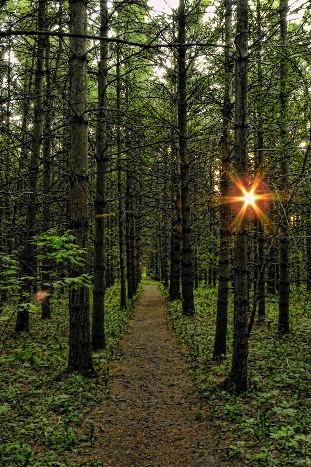
The weather was cool and foggy but the weather report said the fog would burn off by mid-morning and the sun would come out. The trail starts by heading through a tunnel under Highway 6 and climbs up a set of concrete steps to the trail proper. We were almost immediately greeted by an old homestead that is now used by teenagers as party central. There is a lot of garbage and some graffiti that detracts from the ruins. The trail then follows undulating terrain across the side of the escarpment before eventually climbing to the top and skirting a reclaimed quarry.

Misty morning.


The trail re-enters the forest here and the terrain becomes very rocky. There are an abundance of local trails that criss-cross the path. The route then descends to cross a small creek and then a set of train tracks before emerging onto Snake Road 2.8km from where we started.

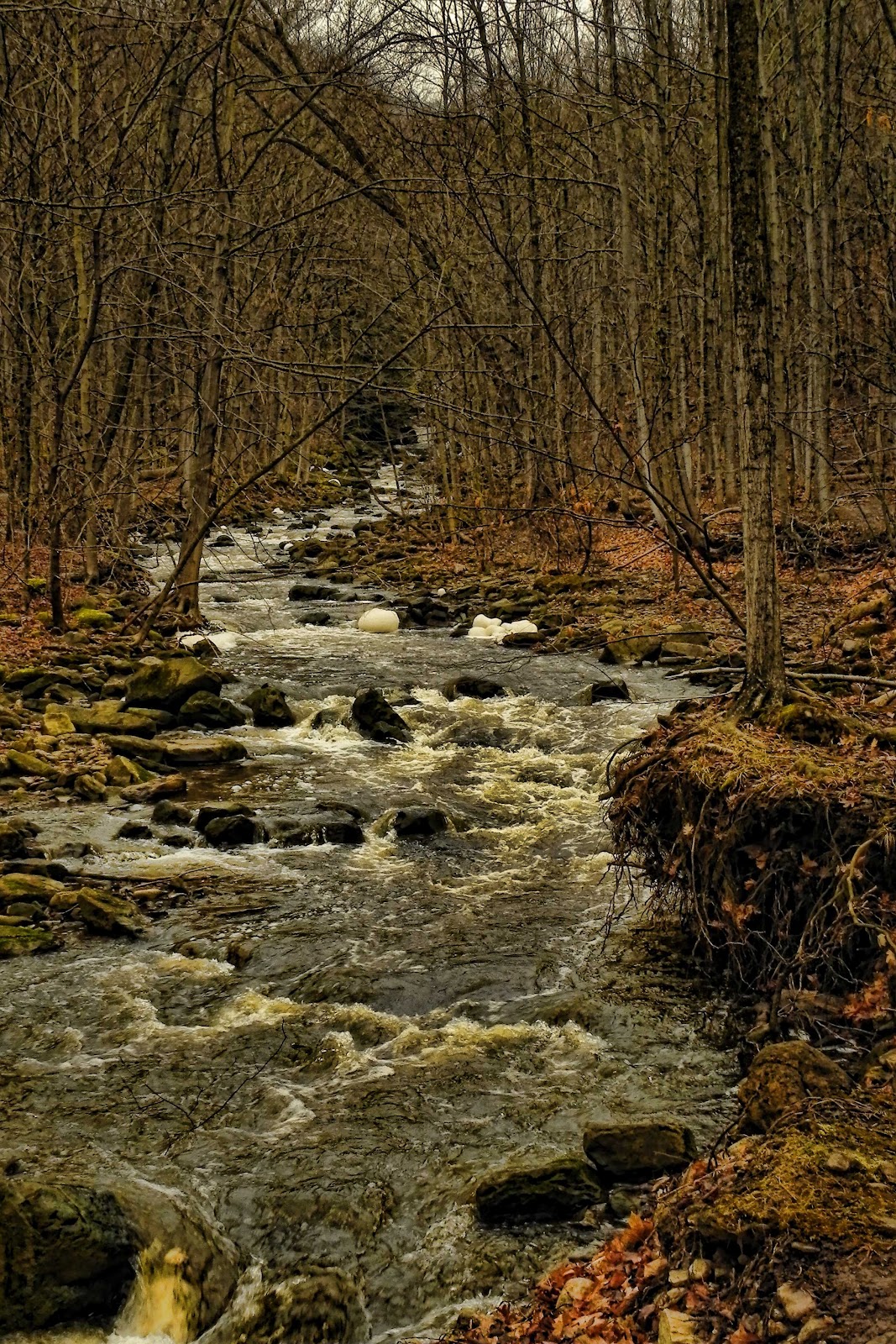
The trail climbs again before passing a farmer's field and a marsh, it then quickly descends to travel south alongside Grindstone Creek. After crossing a bridge over the Grindstone the most technical, and also the most beautiful section of the trail begins. The path follows the fast flowing creek for almost 2km with many sharp elevation changes over rocky and root-riddled terrain. Make sure your camera is ready in this section.

The trail emerges, at km 6.3, on Waterdown Road (also called Mill St.) There is a parking area here and a viewing platform of a medium sized waterfall (which is called, depending on the source, Waterdown Falls, Great Falls, or Grindstone Falls).
Grindstone Creek
Grindstone Creek

The path then climbs a steep embankment, crosses the road, and goes through a grassy right of way before emerging into a subdivision. After about 400m of road travel the trail climbs a stile and returns to the forest. This section remains relatively flat with minor elevation changes before crossing King Rd at km 9.2.

There are some great views to be had in this section of Burlington and even of Toronto if the weather is cooperative. After emerging onto Kerns Road at km 10.9 the trail enters Kernscliff Park, this is an old quarry that is being converted into a park by the City of Burlington. The path descends into a valley before climbing back up and follows a grassy path across the top of the escarpment before entering the forest once more. We stopped here for a rest, to have a snack and to take off our top layers (the weather, and the climb had warmed us). We met a group of 3 older ladies who were out hiking with their black Lab puppy. They told us that it was all downhill from here to Guelph Line .... yeah .... it's not. Although we had done most of our climbing up to this point (almost 220m ... or 722 ft), there was still almost 130m of climbing ahead of us.

The trail then veers north and crosses Dundas Street at km 12.6. There are many black capped chickadees in this section but we couldn't get any to feed from our hands. The trail has minor elevation changes and travels in a NE direction until coming out into Cedar Springs Road at km 13.6. The path follows the road south for about 100m before climbing a stile and re-entering the forest.

This next section can get quite muddy and waterproof footwear is recommended in the spring or after a decent rainfall. The trail goes through some private property, passing a large house before coming across a small pond at the base of a cliff face. The path climbs steeply up to the top and follows a muddy path between farmer's fields and eventually comes out at a nice view of Fisher's Pond at km 15.8.

More muddy paths between farmer's fields follows before entering a forest and descending quickly to a small litter-strewn creek. We crossed the creek twice, climbed out of the valley and eventually come out onto Guelph Line at km 18.

The final section follows a farmer's field for roughly 400m before crossing into a forest. This is fairly level and led us to 1st Sideroad and the end of our hike. In total it was 20.5km (which includes detours to lookouts and geocaching) and our total time was 6:33. Climbing total was 347m (1,138 ft) ... the equivalent of climbing the top of a 105 story building.


Start Finish

View Larger Map

View Larger Map

Tuesday, March 13, 2012

Acton Tract - Halton Regional Forest

Halton Region owns 665 hectares (1645 acres) of forest in 14 tracts. The Acton Tract is located in Nassagaweya-Esquesing Townline north of Milton.

This tract is predominantly a pine plantation with extensive spruce growth. Judging by the damage to the bark of some of the trees there appear to be a plethora of porcupines in the proximity of the populous pines in the tract (Porcupines have a passion for pines). There is also much evidence of deer in the area ... to see these I recommend hiking in the early morning or late evening , when they are more active.

The trail is short, only 800m, and is very easy with are only mild elevation changes. The path is isolated to the NW side of the property. The SE section appears to be predominantly a cedar swamp so I'd bring bug spray if I were to do this route in the spring or early summer.

I visited this area to find a geocache that is hidden in the north side of the property. It wasn't in very good shape, it had gotten wet, so I'm not sure if it will be repaired or removed.

For history buffs there is evidence of prior human usage on the property. Rock walls and rock piles are scattered about ... perhaps the area was farmed at some point. The rocky soil and swampy conditions must have made that difficult.

Click here for pictures of the Acton Tract.


View Larger Map

Sunday, March 11, 2012

Cox Tract - Halton Regional Forest

The Cox Tract, just north of Milton, is one of 14 forest tracts owned and operated by the Region of Halton. The fact this tract is caught betwixt two quarry pits (try saying that ten times fast) means noise from the machinery might be a problem should one visit during working hours. Weekends, though, should be quieter. I was there on a Sunday and the only sounds were my footsteps in the snow, and the occasional hullabaloo of scurrying squirrels.

Tall pines.

As of March 2012 there is no parking area for the Cox Tract ... I had to park at the Britton Tract (about 350m north on 6th Line). Once on the trail proper the walk is very light with few elevation changes. The path starts at the southern edge of the property and weaves to the (almost) northern edge. An access road has been built through the property to unite the two quarry pits, as a result passage to the extreme northern end of the forest is not available from this entrance.


The entire path is 1.45km and is one way. You must retrace your path to get back to the parking area making the entire route 2.9km.


View Larger Map

Thursday, March 1, 2012

Hemlock Bluff - Algonquin Provincial Park

The Hemlock Bluff trail in Algonquin is one of the lesser known hikes in the Park. It isn't as rugged as Centennial Ridges, or as spectacular as Lookout. This means that, generally, the trail will not be as busy as some of the others in the Park. The parking lot is at km 27 along Highway 60.

According to the guidebook the path is 3.5km in length ... my GPS says I walked 3.7km. Either way the trail can usually be done in about an hour for experienced hikers, and up to two otherwise (I took 1:04 and that included many photo stops and a snack break).

View from the Hemlock bluff.


The trail starts with a moderate rise to the Hemlock bluff ... a 60m rise in elevation over the first kilometre. The view is attractive but not spectacular. The vista is over a narrow arm of the lake so there aren't any sweeping views like you will find on other hikes. After following the bluff for a short time you descend rather sharply to lake level. There is a great lunch spot here under the Hemlocks.

The trail follows the shoreline for a while and then pulls away with many slight elevation changes, none major. It returns to the shoreline of another arm of the lake before crossing a boardwalk and returning inland again. The last kilometre of the hike is rather flat and returns you to the trailhead.

As a word of warning. The parking area is on the south side of Highway 60 while the trailhead is on the north side. Please exercise caution while crossing the busy highway.

For more photos of the Hemlock Bluff trail, please click here.


View Larger Map

Wednesday, February 29, 2012

Granite Ridge - Killarney Provincial Park

Granite Ridge is a moderate 2.3km trail in Killarney Provincial Park. It is an excellent introduction to the features of the park without having to negotiate the far more advanced La Cloche Silhouette trail.

The trail starts out heading west through a pine plantation before heading south  and then west as you walk through  the remains of an early settler's farm. There are 2 derelict cars left to be reclaimed by the forest that make an interesting photo opportunity.

Remains of Billy Blair's car.

After 750m the trail starts to ascend the granite ridge. There are a few steep sections but it is easily manageable if you take your time. There are two spectacular views from the top of the ridge. Unfortunately, I hiked the trail after a large thunderstorm and the area was still clothed in a mist so I was not able to see these views. I have been told, however, that there are fantastic views of the La Cloche mountains to the north, and Georgian Bay to the south.

The return is through a hemlock forest with only one steep section before returning through the farm and plantation. A good set of shoes are recommended.

For all pictures from my hike to Granite Ridge, click here.


View Larger Map